 |
|
| This page will update in 11 minutes | |
| Conditions | Rain |
| Radar Information | |
| Suburb | Mackay City |
| Last Updated | 12th at 05:14 PM |
| Temperature | 25.9 °C |
| Heat Index | 27.5 °C |
| Dewpoint | 22.6 °C |
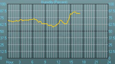
| Humidity | 82 % |
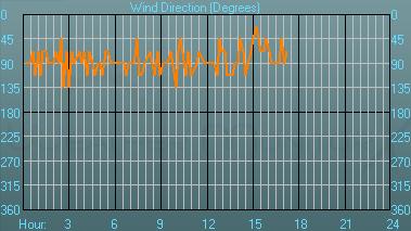
| Wind Direction | ENE |
| Wind Speed | 13 km/H |
| Wind Chill | - °C |
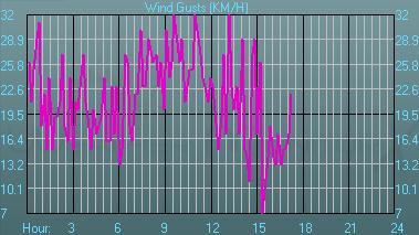
| Wind Gusts | 22 km/H |
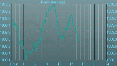
| Barometer | 1008.8 Hpa |
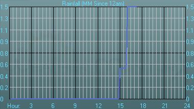
| Rainfall since 9am | 1.5 mm |
| Extremes since start of program | |
| Maximum Temperature at 10:47 | 30.9 °C |
| Minimum Temperature at 15:22 | 23.9 °C |
| Maximum Dewpoint at 17:14 | 22.6 °C |
| Minimum Dewpoint at 01:28 | 20.0 °C |
| Maximum Humidity at 16:13 | 85 % |
| Minimum Humidity at 10:47 | 57 % |
| Maximum Pressure at 10:47 | 1010.2 Hpa |
| Minimum Pressure at 03:50 | 1008.1 Hpa |
| Maximum Wind Gusts at 13:10 | 32 km/H |
| Extremes since 2009 | |
| Maximum Temperature at January 9, 13:20 | 31.8 °C |
| Minimum Temperature at January 7, 04:30 | 21.0 °C |
| Maximum Dewpoint at January 8, 09:31 | 26.0 °C |
| Minimum Dewpoint at January 7, 01:00 | 18.6 °C |
| Maximum Humidity at January 8, 06:39 | 93 % |
| Minimum Humidity at January 10, 13:46 | 54 % |
| Maximum Pressure at January 7, 07:00 | 1013.1 Hpa |
| Minimum Pressure at January 9, 15:21 | 1005.0 Hpa |
| Maximum Wind Gusts at January 10, 16:18 | 39 km/H |
 |
|
 |
|
 |
|
 |
|
 |
|
 |
|
 |
|
| Weather Warnings for Qld | |
Ocean Wind Warning 1 |
|
IDQ20008 SECURITE FINAL HIGH SEAS WEATHER WARNING FOR METAREA 10 ISSUED BY THE AUSTRALIAN BUREAU OF METEOROLOGY, BRISBANE 0507 UTC 12 January 2009 GALE WARNING FOR NORTH EASTERN AREA SITUATION A broad trough near 18S 146E to 19S 150E. AREA AFFECTED Within 18S 146E to 18S 150E to 20S 150E to 20S 148E. FORECAST SE/NE winds 34/40 knots. Rough to very rough seas. These conditions are expected for the next 18 to 24 hours. REMARKS All ships in the area please send weather reports every three hours. Regular weather observing ships use normal channels. Other ships please use either email to [email protected] or fax to +61732200221 or satellite to SAC 41 through Land Earth Station Perth 222. WEATHER BRISBANE |
|
Coastal Wind Warning 2 |
|
IDQ20011 Australian Government Bureau of Meteorology Queensland PRIORITY Coastal Waters Wind Warning For Torres Strait to Qld/NT border. Issued at 3:40 pm EST on Monday 12 January 2009 Synoptic Situation The monsoon trough was lying over the Gulf of Carpentaria. Ex-Tropical Cyclone Charlotte was located over land southeast of Gilbert River Mouth. The system is expected to remain slow moving during today and Tuesday, while gradually weakening. It will remain as a weak low over the Gulf Country during the week. Gale Warning Pormpuraaw to Sweers Island SW/S winds 30/40 knots, with stronger squalls to 50 knots. Winds easing to 25/30 knots early Tuesday morning and then below 26 knots late Tuesday. Seas 3 to 4 metres, decreasing during Tuesday. A 3 to 4 metre N/NW swell. Strong Wind Warning Torres Strait to Pormpuraaw NW/SW winds 25/30 knots, with stronger squalls to 40 knots. Winds easing below 26 knots late Tuesday. Seas 3 metres, decreasing late Tuesday. A 3 to 4 metre NW swell. Strong Wind Warning Sweers Island to Qld/NT border S/SW winds 25/30 knots, with stronger squalls to 40 knots. Winds easing below 26 knots late Tuesday. Seas to 3 metres, decreasing late Tuesday. A 3 metre N/NW swell. The next warning will be issued by 11 pm EST Monday. Please be aware Wind gusts can be a further 40 percent stronger than the averages given here, and maximum waves may be up to twice the height. -------------------------- End of warning ---------------------------- For coastal waters forecasts call 1900 969 923 (cost 77c per minute, incl GST, more from mobiles or payphones) Media: TOP PRIORITY (Broadcast on receipt and repeated at least hourly.) Media: PRIORITY (Broadcast as soon as possible, but not later than one hour after receipt. Repeat in normal news and weather.) |
|
Coastal Wind Warning 3 |
|
IDQ20012 Australian Government Bureau of Meteorology Queensland Coastal Waters Wind Warning For Torres Strait to St Lawrence Issued at 2:30 pm EST on Monday 12 January 2009 Synoptic Situation A low [Ex-Tropical Cyclone "Charlotte"] is overland, southeast of the Gulf of Carpentaria. The Monsoon Trough extends from this low into the Coral Sea. Strong NW'ly winds are occurring to the north of the Monsoon Trough. Another trough off the coast from Cardwell to Bowen is causing strong to gale force winds south of Cardwell. Gale Warning Cardwell to Bowen SE/NE winds 34/40 knots with squalls to 50 knots, easing a little during the day on Tuesday. Seas to 3.5 metres. Strong Wind Warning Torres Strait to Cooktown NW winds 25/33 knots. Stronger gusts to 50 knots can be expected in squally monsoonal showers. Seas to 3 metres. A 2 metre NW swell through Torres Strait.. Strong Wind Warning Cooktown to Cardwell NW/NE winds 25/33 knots north of Cairns, easing below 25 knots early Tuesday. SE/NE winds 25/33 knots between Cairns and Cardwell. Seas 2 to 3 metres. Stronger gusts to 50 knots can be expected in squally rain. Strong Wind Warning Bowen to St. Lawrence SE/E winds 25/30 knots developing tonight. Seas rising to 3 metres in open waters. A 2 metre SE swell developing. The next warning will be issued by 11 pm Monday AEST. Please be aware Wind gusts can be a further 40 percent stronger than the averages given here, and maximum waves may be up to twice the height. -------------------------- End of warning ---------------------------- For coastal waters forecasts call 1900 969 923 (cost 77c per minute, incl GST, more from mobiles or payphones) Media: TOP PRIORITY (Broadcast on receipt and repeated at least hourly.) Media: PRIORITY (Broadcast as soon as possible, but not later than one hour after receipt. Repeat in normal news and weather.) |
|
Severe Weather Warning 1 |
|
IDQ20032 Australian Government Bureau of Meteorology Queensland TOP PRIORITY FOR IMMEDIATE BROADCAST SEVERE WEATHER WARNING for Abnormally High Tides and damaging winds For people in coastal and island communities between Torres Strait and Mornington Island, and parts of the Gulf Country. Issued at 5:15 pm on Monday 12 January 2009 Synoptic Situation: Ex-Tropical Cyclone Charlotte was located over land about 80 kilometres east-northeast of Normanton. The system is expected to remain slow moving for the rest of today and Tuesday while gradually weakening. Strong to gale force southwest to northwest winds over the Gulf region are continuing but expected to ease on Tuesday. Damaging wind gusts to 90 km/hr are likely over the Gulf Country east of Burketown, but are expected to ease Tuesday morning. Coastal and island residents between the Torres Strait islands and Mornington Island are warned tides may exceed the high water mark on the high tide today. Damaging waves and flooding of some low lying areas close to the shoreline are likely on the high tide. Damaging waves and abnormally high tides are expected to ease overnight. The State Emergency Service advises that people in the affected area should: � avoid driving, walking or riding through flood waters � if near the coastline, stay well away from the water's edge � secure loose outdoor items � beware of fallen trees and powerlines Contact the SES on 132 500 for emergency assistance if required. The next warning is due to be issued by 11 pm Monday EST. This warning is also available through TV and Radio broadcasts; the Bureau's website at www.bom.gov.au or call 1300 659 219. The Bureau and State Emergency Service would appreciate this warning being broadcast regularly. |
|
Severe Weather Warning 2 |
|
IDQ20033 Australian Government Bureau of Meteorology Queensland TOP PRIORITY FOR IMMEDIATE BROADCAST SEVERE WEATHER WARNING for Damaging Winds, Very Heavy Rainfall and Flash Flooding. For people in the North Tropical Coast and Tablelands, Herbert and Lower Burdekin forecast districts. Issued at 5:00 pm on Monday 12 January 2009 Synoptic Situation: Ex-Tropical Cyclone Charlotte was located over land about 80 kilometres east-northeast of Normanton. The system is expected to remain slow moving for the rest of today and Tuesday while gradually weakening. An active monsoon trough lies over the North Tropical Coast district near Cairns and is expected to move south into the northern part of the Herbert and Lower Burdekin district overnight and Tuesday. Squally MONSOONAL showers and areas of heavy rain are affecting the North Tropical Coast & Tablelands south of Cairns, and the Herbert & Lower Burdekin districts. Heavy rain leading to localised flash flooding is expected to continue overnight and on Tuesday. A flood warning is current for coastal rivers and streams between Cairns and Townsville. Damaging wind gusts of up to 90km/h are also likely. The warning for the Northern Goldfields and Upper Flinders district is cancelled. The State Emergency Service advises that people in the affected area should: � seek shelter, preferably indoors and never under trees � secure loose outdoor items � beware of fallen trees and powerlines � avoid driving, walking or riding through flood waters Contact the SES on 132 500 for emergency assistance if required. The next warning is due to be issued by 11 pm Monday This warning is also available through TV and Radio broadcasts; the Bureau's website at www.bom.gov.au or call 1300 659 219. The Bureau and State Emergency Service would appreciate this warning being broadcast regularly. |
|
Flood Warning - Coastal rivers - Cooktown to Townsville |
|
TO::BOM602+BOM628+BOM604 IDQ20700 Australian Government Bureau of Meteorology Queensland ## FLOOD WARNING FOR COASTAL RIVERS AND STREAMS BETWEEN CAIRNS AND TOWNSVILLE Issued at 4:07 PM on Monday the 12th of January 2009 by the Bureau of Meteorology, Brisbane. Heavy rainfall is causing rises in the Mulgrave, Russell, Johnstone and Tully Rivers. Further rainfall is forecast for this afternoon and tonight. River rises to above flood levels are possible during the next 24 hours. The heaviest rainfall since 9am Monday has occurred in the Mulgrave and Russell, Johnstone and Tully Rivers with totals up to 170 mm. Falls of up to 90mm have been recorded in the last 3 hours in coastal areas between Innisfail and Ingham. Minor flooding is expected to develop in the Tully River during this afternoon and tonight. The Barron and Johnstone Rivers have generally remained below minor flood level and are falling. The heaviest rainfall is currently in the Townsville area. Rises are occurring in the streams and rivers around Townsville, including the Bohle River and Bluewater Creek. Further heavy rainfall is likely in the next 6 to 12 hours south of Cairns and could cause further stream rises and higher flood levels in this area. A flood warning is current for the The Mulgrave and Russell Rivers. Motorists are warned not to attempt to drive through floodwater on roads, especially at night. Next Issue: The next warning will be issued at about 8pm Monday. Latest River Heights: nil. Latest Rainfall: The highest rainfall since 9am Monday include Cairns Airport 73mm, Gordonvale 88mm, Innisfail 153mm, Tully 108mm, Euramo 173mm, Ingham 105mm and Upper Bluewater 158mm. Warnings and River Height Bulletins are available at http://www.bom.gov.au/hydro/flood/qld . Flood Warnings are also available on telephone 1300 659 219 at a low call cost of 27.5 cents, more from mobile, public and satellite phones. |
|
Flood Warning - Mulgrave and Russell Rivers |
|
TO::BOM602 IDQ20712 Australian Government Bureau of Meteorology Queensland FLOOD WARNING FOR THE MULGRAVE AND RUSSELL RIVERS Issued at 1:25 PM on Monday the 12th of January 2009 by the Bureau of Meteorology, Brisbane. Recent heavy rainfall in the Mulgrave River is causing rapid rises and moderate to major flooding. Moderate flooding is expected on the Russell River during Monday. The Mulgrave River at Gordonvale is expected to reach above the Bruce Highway during this afternoon. At 1pm the river level at Bruce Highway bridge at Gordonvale was about 1 metre below the bridge deck level and rising fast. In the Russell River, rises are expected to cause moderate flooding during the afternoon. Next Issue: The next warning will be issued at about 5pm Monday. Latest River Heights: Mulgrave R at The Fisheries # 4.45m rising 01:23 PM MON 12/01/09 Mulgrave R at Peets Bridge # 6.9m rising 01:13 PM MON 12/01/09 Mulgrave R at Gordonvale # 13.0m rising fast 01:00 PM MON 12/01/09 Russell R at Bucklands * 6.78m rising 11:00 AM MON 12/01/09 Russell R at Clyde Rd* 0.92m steady 01:16 PM MON 12/01/09 Latest Rainfall: The heaviest rainfall recorded since 9am include Peats Bridge 102mm, The Fisheries 105mm, and Clyde Road 110mm. Warnings and River Height Bulletins are available at http://www.bom.gov.au/hydro/flood/qld . Flood Warnings are also available on telephone 1300 659 219 at a low call cost of 27.5 cents, more from mobile, public and satellite phones. |
|
Flood Warning - Diamantina River |
|
TO::BOM626 IDQ20865 Australian Government Bureau of Meteorology Queensland FLOOD WARNING FOR THE DIAMANTINA RIVER Issued at 10:11 AM on Monday the 12th of January 2009 by the Bureau of Meteorology, Brisbane. Moderate to major flooding is occurring along the Diamantina River between Elderslie and Birdsville Station. Small renewed rises and major flooding are occurring on the Diamantina River at Diamantina Lakes this week. The Diamantina River at Elderslie has fallen to moderate flood level and the river level was 2.55 metres at 9:00am Monday. Minor flooding in the Diamantina River at Tulmur continues to fall slowly and is expected to fall below minor flood level during today. The river level was 5.00 metres at 9:00am Monday. Major flooding continues at Diamantina Lakes. The river level was 6.35 metres and steady on Monday. Moderate flooding is slowly easing in the Diamantina River at Roseberth Station, with renewed rises expected later this week with upstream waters yet to arrive. The Diamantina River at Birdsville is falling slowly and remains above moderate flood level. The river level was 6.26 metres at 9:00am Monday. Moderate flooding is expected to continue at Birdsville during the week with some renewed rises later in the week with upstream waters yet to arrive. Weather Forecast: Isolated showers and thunderstorms. Next Issue: The next warning will be issued at about 10am Tuesday. Latest River Heights: Diamantina R at Elderslie 2.55m falling slowly 06:00 AM MON 12/01/09 Diamantina R at Tulmur 5m falling slowly 09:00 AM MON 12/01/09 Diamantina R at Diamantina Lakes * 6.35m steady 04:00 AM MON 12/01/09 Diamantina R at Roseberth 4.5m falling slowly 06:00 AM MON 12/01/09 Diamantina R at Birdsville 6.26m falling slowly 07:40 AM MON 12/01/09 Latest Rainfall: No significant rainfall was recorded during the 24 hours to 9am Monday. Warnings and River Height Bulletins are available at http://www.bom.gov.au/hydro/flood/qld . Flood Warnings are also available on telephone 1300 659 219 at a low call cost of 27.5 cents, more from mobile, public and satellite phones. |
|
Flood Warning - Georgina/Eyre Ck |
|
TO::BOM627 IDQ20870 Australian Government Bureau of Meteorology Queensland FLOOD WARNING FOR THE GEORGINA RIVER AND EYRE CREEK Issued at 9:46 AM on Monday the 12th of January 2009 by the Bureau of Meteorology, Brisbane. Moderate to major flooding continues in the Georgina River from Urandangi to Marion Downs. The Georgina River at Urandangi is falling slowly with moderate flooding. The river level at Urandangi was 5.85 metres at 8:30am Monday. The Georgina River at Roxborough Downs has peaked although it remains above major flood level. The river level is falling slowly and was 9.11 metres at 9:00am Monday. Downstream at Glenormiston the river level is steady at 7.50 metres and remains above major flood level. The Georgina River at Marion Downs is falling slowly but remains above major flood level. Renewed rises are expected later this week and river levels are expected to remain at major flood level until next week as upstream waters arrive. Moderate to major flooding is expected downstream of Marion Downs and in Eyre Creek this week. Eyre Creek at Bedourie is above minor flood level and was 3.91 metres at 9:00am Monday. Motorists are warned not to attempt to drive through flood water on roads. Weather Forecast: Isolated showers and thunderstorms are forecast across the catchment today. Next Issue: The next warning will be issued at about 10am Tuesday. Latest River Heights: Georgina at Urandangi 5.85m steady 08:30 AM MON 12/01/09 Georgina R at Roxborough Downs * 9.11m steady 05:10 AM MON 12/01/09 Georgina R at Glenormiston 7.5m steady 07:00 AM MON 12/01/09 Burke R at Boulia * 2.44m falling slowly 08:30 AM MON 12/01/09 Eyre Ck at Bedourie 3.91m rising slowly 06:00 AM MON 12/01/09 King Creek at Cluny 3m rising fast 06:00 AM MON 12/01/09 Eyre Ck at Glengyle 2.3m rising 03:10 PM SUN 11/01/09 Latest Rainfall: No significant rainfall has been recorded in the last 24 hours. Warnings and River Height Bulletins are available at http://www.bom.gov.au/hydro/flood/qld . Flood Warnings are also available on telephone 1300 659 219 at a low call cost of 27.5 cents, more from mobile, public and satellite phones. |
|
Flood Warning - Gulf Rivers |
|
TO::BOM601 IDQ20875 Australian Government Bureau of Meteorology Queensland FLOOD WARNING FOR THE NICHOLSON, ALBERT, CLONCURRY, FLINDERS AND NORMAN RIVERS Issued at 10:03 AM on Monday the 12th of January 2009 by the Bureau of Meteorology, Brisbane. Moderate to major flooding continues along the Albert River at Burketown and in the Nicholson River at Escott Station. Moderate to major flooding continues in the Cloncurry and Flinders Rivers. Rises and minor flooding are occurring on the lower Norman River in the Normanton area. NICHOLSON/GREGORY/ALBERT The Nicholson River at Escott Station has experienced some renewed rises where the river level at 6am was 10.2 metres and rising with major flooding. Moderate flooding continues to ease on the Albert River at Burketown where at 7am the river level was at 5.8 metres and falling, however renewed rises are expected to result in a return to major flood levels during Tuesday. Moderate flooding is expected to continue at Doomadgee during the next few days. River levels will remain high at Burketown and Escott Station during this week. FLINDERS/CLONCURRY Major flooding continues on the Cloncurry River in the Canobie area, where at 9am the river level was at 7.4 metres and rising. The main flood waters in the Flinders River are currently between the Etta Plains and Walkers Bend area. Renewed rises and major flooding are occurring on the lower Flinders River at Walkers Bend, where at 8am the river level was at 13.27 metres and rising with major flooding. River levels will remain high along the lower Flinders River during this week. NORMAN Minor flooding is occurring along the lower Norman River between Glenore Weir and Karumba. River levels are expected to remain high during this week. Motorists are warned not to attempt to drive through floodwater on roads. Weather Forecast: Scattered showers, rain areas and isolated thunderstorms tending widespread near the Gulf Coast. Some moderate to heavy falls throughout the Gulf District. Next Issue: The next warning will be issued at about 10am Tuesday. Latest River Heights: Nicholson R at Escott Station 10.2m rising 06:00 AM MON 12/01/09 Albert R at Burketown Airstrip 5.8m falling slowly 07:00 AM MON 12/01/09 Leichhardt R at Floraville * 5.5m falling slowly 06:00 AM MON 12/01/09 Flinders R at Etta Plains * 9.36m rising 08:20 AM MON 12/01/09 Cloncurry R at Canobie * 7.4m rising 09:00 AM MON 12/01/09 Flinders R at Walkers Bend * 13.27m rising 08:00 AM MON 12/01/09 Norman R at Glenore Weir * 10.12m rising 07:00 AM MON 12/01/09 Norman R at Normanton NA Karumba tide * 1.48m steady 07:50 AM MON 12/01/09 * denotes automatic station Latest Rainfall: The heaviest rainfall for the 24 hours to 9am Monday includes Normanton 135mm, Walkers Bend 96mm, Croydon 94mm and Burketown 14mm. Warnings and River Height Bulletins are available at http://www.bom.gov.au/hydro/flood/qld . Flood Warnings are also available on telephone 1300 659 219 at a low call cost of 27.5 cents, more from mobile, public and satellite phones. |
|
Queensland flood warning summary |
|
IDQ20885 Australian Government Bureau of Meteorology Queensland Flood Summary Issued at 1:27 PM on Monday the 12th of January 2009 The following Watches/Warnings are current: FLOOD WARNING FOR COASTAL RIVERS AND STREAMS BETWEEN CAIRNS AND TOWNSVILLE FLOOD WARNING FOR THE DIAMANTINA RIVER FLOOD WARNING FOR THE GEORGINA RIVER AND EYRE CREEK FLOOD WARNING FOR THE MULGRAVE AND RUSSELL RIVERS FLOOD WARNING FOR THE NICHOLSON, ALBERT, CLONCURRY, FLINDERS AND NORMAN RIVERS See Flood Warnings for more details. Additional information: Cape York: Some minor flooding on Magnificent Creek at Kowanyama. Thomson/Cooper: Some minor to moderate flooding from Jundah to Windorah. Warnings and River Height Bulletins are available at http://www.bom.gov.au/hydro/flood/qld . Flood Warnings are also available on telephone 1300 659 219 at a low call cost of 27.5 cents, more from mobile, public and satellite phones. |
|
Tropical Cyclone Forecast Track Map System 1 |
|
 |
|
NT Ocean Wind Warning affecting Qld border area |
|
IDQP0002 Australian Government Bureau of Meteorology Northern Territory Darwin Regional Forecasting Centre 40:2:1:24:17S142E999:11:00 SECURITE HIGH SEAS WEATHER WARNING HIGH SEAS WEATHER WARNING FOR METAREA 10/11 Issued by the AUSTRALIAN BUREAU OF METEOROLOGY, DARWIN Issued at 0556 UTC 12 JANUARY 2009 PLEASE BE AWARE Wind gusts can be a further 40 percent stronger than the averages given here, and maximum waves may be up to twice the height. GALE WARNING FOR NORTHERN AREA SITUATION At 0500 UTC Ex-Tropical Cyclone "Charlotte" was weakening over land near 17.0S 141.7E, slow moving. Gale force winds are continuing to affect adjacent waters. AREA AFFECTED Over water within area bounded by 14S 142E to 18S 142E to 18S 139E to 14S 142E. FORECAST South to southwest winds 30/40 knots are expected to continue for the next 12 hours. Seas to 4m on a 4m northwesterly swell. Squalls to 50 knots. REMARKS Next warning will be issued by 1130 UTC 12 January 2009. DARWIN Tropical Cyclone Warning Centre |
|
Tropical Cyclone Advice for System 1 |
|
IDQP0005 Australian Government Bureau of Meteorology Queensland Tropical Cyclone Warning Centre Media: The Standard Emergency Warning Signal should NOT be used with this warning. TOP PRIORITY TROPICAL CYCLONE ADVICE NUMBER 17 Issued by the Bureau of Meteorology, Brisbane Issued at 11:23am on Monday the 12th of January 2009 The Cyclone WARNING has been cancelled. At 10:00 am EST EX-TROPICAL CYCLONE CHARLOTTE was estimated to be 70 kilometres southeast of Gilbert River Mouth and 145 kilometres north northwest of Croydon, moving east southeast at 11 kilometres per hour. EX-TROPICAL CYCLONE CHARLOTTE crossed the coast near the Gilbert River Mouth early this morning, and is expected to continue moving east southeast over land today while weakening. Winds around the centre of the cyclone have now weakened below gale force, so the Tropical Cyclone Warning for this system has been cancelled. Strong monsoon winds have also eased, although a Severe Weather Warning remains current for abnormally high tides between Torres Strait and Mornington Island. Further heavy rainfall and flooding are expected in the southeast Gulf Country and parts of the Cape York Peninsula forecast districts. No further Tropical Cyclone Advices will be issued unless the situation changes. Details of Ex-Tropical Cyclone Charlotte at 10:00 am EST: .Centre located near...... 17.0 degrees South 141.7 degrees East .Location accuracy........ within 28 kilometres .Recent movement.......... towards the east southeast at 11 kilometres per hour .Wind gusts near centre... 85 kilometres per hour .Severity category........ below cyclone intensity .Central pressure......... 991 hectoPascals This warning is also available through TV and Radio Broadcasts; the Bureau's website at www.bom.gov.au or call 1300 659 212. The Bureau and the State Emergency Service would appreciate this warning being broadcast regularly. |
|
